
 |
|||||||||||||||||||||||||
Myriad Unnamed Streams
page 1
a self-guided tour exploring the intimate history of the suburban landscape from the point of view of Water in Northeast Los Angeles
|
||
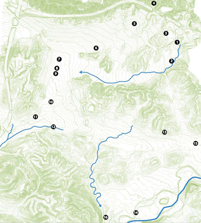
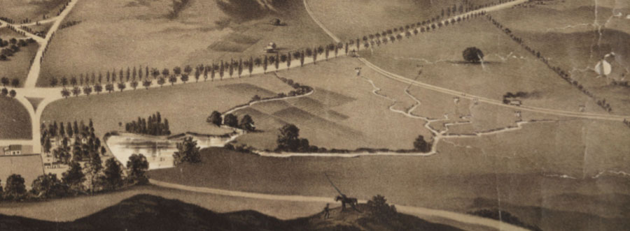
Street map showing storm drains/1888 water courses as mapped by State Engineer William Hammond Hall, overlaid onto modern topographical data. Street, stormdrain and topographical data: Bureau of Engineering. |
||
When my family first moved to West Los Angeles ten years ago, we heard rumors of a freshwater spring by the high school sports field next door. This became a place I visited with wonder. I was mystified by how naturally the water flowed through a well-groomed miniature landscape, before unceremoniously disappearing into a drainage grating.
Years later, my family bought an old house in Northeast Los Angeles. I learned that a neighbor's backyard was once the source of a small spring. This topic could only be broached with great embarrassment on the part of the homeowner, who'd built their addition right over the spring.
As I passed these stories on to others, I learned of more water stories, none of which made sense within the city landscape I navigated every day. Hadn't I been told countless times that this region is a desert? What was reality and what was urban myth? Contacting the local historical society, I learned that outside of the memories of devoted and sharp-minded neighborhood history buffs, there was no existing compilation of information on local water sources. I began work as an amateur historian, focusing on the neighborhood of Eagle Rock.
I discovered that small springs and seeps were common and perhaps known most intimately by adventurous local children. To those who worked toward modernization of the former farm communities, such water flows were an obstacle to development.
Such small waterflows were never mapped, much less named. But they slowly merged into branches, and then tributaries of larger waterflows that were both mapped and named. The wide concrete troughs carved through our city - the Los Angeles River and the Arroyo Seco - are now the focus of grassroots watershed restoration efforts.
Meanwhile, maps of the storm drains under our city streets reveal an intricately laid, neatly linear skeleton of the myriad waterflows that once flowed organically over a gently curving landscape.
Northeast Los Angeles oldtimers filled me in on how they once experienced this landscape - before the areas we are now familiar with were regraded, filled in, and drained. Enjoy this self-guided tour. If you live nearby, consider doing the route by bike, to experience the real landscape, with its subtle patterns of topography and temperature change.
- Jane Tsong, Los Angeles, 2009
myriadsmallthings/at/gmail/dot/com
page 2
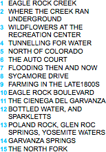
Though Huntington developed "Eagle Rock Park" as a tourist destination, the canyon was a key part of his plan to convey cheap hydroelectric power profitably to Los Angeles. (ERVHS)
1 Eagle Rock Creek
The intersection of Figueroa Street and the westbound onramp for the 134 is a dramatic swathe of concrete, each lane little more than a conduit for cars whose drivers are focused on any destination but the current location. Only a couple generations ago, this area east of Figueroa and north of Colorado, was the well-loved "Eagle Rock Park", whose central feature was the shady canyon stream just a couple paces east.
Ludwig Louis Salvator, the Archduke of Austria, described this canyon as "a wilderness of luxuriant vegetation that forms an almost impenetrable thicket often the haunt of wild beasts" in his 1876 memoirs. Pioneer farmers who settled nearby in the 1880s would have found wild roses, wild blackberries and raspberries, tiger lilies and wild grapes growing profusely in the canyon.
Around that time, the canyon stream filled a modest lake which "provided water for both domestic animals (dogs, sheep, horses and cattle) and native wildlife such as fox, coyote, cougar and deer."
The town of Eagle Rock changed forever when developer and railroad magnate Henry Huntington decided to build a streetcar line connecting it to Los Angeles. Huntington purchased much of Eagle Rock canyon. Mere rumor of his interest turned neighboring hills and orchards into valuable real estate overnight. Under Huntington's hand, the riparian landscape was groomed for mass appeal. Underbrush was cleared. In came rustic tables and benches, ovens for barbecuing, teeterboards, a footbridge, and pathways. Newspapers and railway guides promoted "Eagle Rock Park" as a picnic location. At various times facilities may even included a dancing pavilion, malt shop, and merry-go-round.
For two decades after the Huntington era, the canyon retained a wilderness-like character. Eagle Rock oldtimers remember the canyon as a place for exploration. Bert Fraleigh fondly remembers "the year-round stream that ran in front of the rock, where I caught a few minnows and salamanders in the 20s..." Bob Brown would climb up into the caves on the side of the Eagle Rock, and build a fire to cook fish caught farther up the canyon.
As recently as the late 40s, the canyon could be described as a "sylvan glen." Wanda Kuenzli told me, "You could get on a rope, swing over the water, and drop into it. The brook ran almost down to Colorado. We rode horses that entire length… Trees covered the brook. They were huge..."
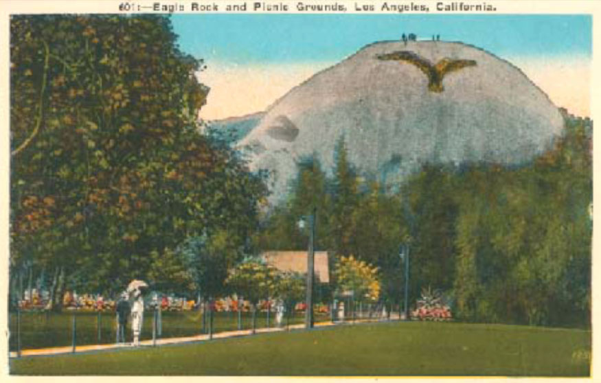
Sycamores mark the former flood plain.
The following decades would bring development of the lower end of the park into a business park, the channeling of remaining creek flow into storm drains that eventually connect with the Los Angeles River, and the construction of the 134 freeway over the streambed. Nowadays, the creek is unknown even to many long-term Eagle Rock residents.
But in the parking lot along the back of a business park on the Northeast corner of Colorado Boulevard and Figueroa Street, a remaining trickle of water runs in an open streambed, relatively unharassed, for a hundred yards or so. The canyon is pleasantly cooler than neighboring streets. And water still flows down from the canyon, as it always has.
page 3
2 Where the Creek Disappeared Underground
In the mid 1800s, Eagle Rock Creek continued roughly in the proximity of Lanark Street and turned west toward Yosemite Drive.
A hundred years later, an open streambed still existed north of La Loma, but after passing under a bridge at La Loma, ran into a concrete gutter and then storm drain. Here is a story from the late 50s, as told by Kenneth Kent Sr.:
At the end of Lanark St was a street called La Loma and it bridged over the concrete ditch that ran along Lanark, on the other side was the river that flowed into the ditch, now we had a perfectly good Kayak but not enough water to float it in, and it didn't work out very well as a coaster. My step-dad had these sand bags he wasn't using anyway and we always had a sand pile at home in the back yard, So we dammed up the river at the bridge making sure to leave a spillway so the water would only get so deep, just enough to float a Kayak. The water balked up to some giant oleander bushes on the bank and you could paddle in to them like a river on the Nile, one day we were paddling out of darkest Africa and on the bridge was a Cop and a Lady that lived next to our lake, she said we were making mosquitoes and the lake had to go, that was too bad cause it was a neat lake.
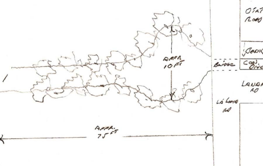
Kenneth's sketch of the dammed up water where neighborhood kids played.
page 4
3 Wildflowers at the Eagle Rock Recreation Center
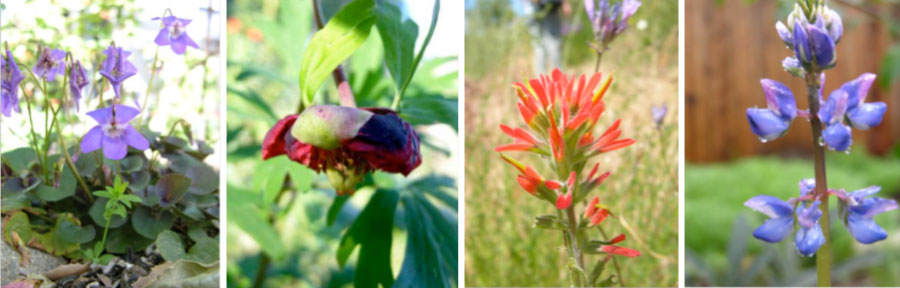
These photos by Ken Gilliland show flowers in the same genus as the ones Elmer remembers from his childhood... violets... california peonies... indian paintbrush... lupines... Aside from recollections of the Lorenzs, I found no detailed documentation of the plant life that once existed on this vast site.
In 1945 Elmer Lorenz bought a property on Monte Bonito Drive. On the back end of the property, a seasonal stream ran down a ravine.
The stream originated at the site of the current Eagle Rock Recreation Center, which used to be rolling terrain. Here, Elmer remembers seeing violets, lupines, California peonies, Mariposa Lilies, California poppies, Indian paintbrushes. In an interview recorded by the Historical Society, Elmer's mother, Mrs. John Lorenz describes how "local residents came and picked [flowers] by the armfuls." A photo of Anneta Lorenz with such an armful of flowers in the Eagle Rock foothills appears in Eric H. Warren's new pictorial history, Eagle Rock.
An avid horticulturalist, Elmer planned to plant Louisiana irises alongside the stream in his backyard. Such irises grow in swamp conditions but go dormant in the summer— in sync with the California seasons. Soon, however, the state bought the back half of his property for freeway construction. The freeway offramp now stands where a beautiful clump of old sycamores once stood.
The Eagle Rock Recreation Center was built on the hills where the spring once arose, providing much-anticipated sports fields for neighborhood use.
Garrett Eckbo, Landscape Architect, wrote of the challenges of the project: "The site was 18 acres of rough topography-- two large gullies framing a knoll on which stands the well-known community building designed by Richard Neutra. In order to capture the space needed for community facilities, the gullies were filled and leveled, an operation requiring over 100,000 cu yd of earth.
page 5
4 Tunneling for Water
Old timers still refer to the area northwest of the present day intersection of Hill Drive and Arbor Dell Road as the "Lemon Grove." A tunnel for irrigation had been drilled there by Benjamin Dreyfus, soon after he was awarded the Eagle Rock area in the Division of Rancho San Rafael in 1870.
The land changed hands twice before being bought by W. H. Stimson, who maintained a 75-acre grove of 800 lemons, 30 avocados, and other choice trees, between 1907 and 1928.
It is uncertain how much the rancher relied on the tunnel to irrigate these 75 acres. What we do know is that the rancher worked hard to increase his water supply. Francis Johnston reports, "[Stimson] ran a second water tunnel into the hills and built a reservoir to catch the run-off from the surrounding slopes. Unfortunately, this latter effort was unsuccessful, and a piping system had to be connected directly with the water tunnels."
Bob Moffitt remembers at least one of the Stimson tunnels still flowed into the late 50s, and was used by Larry Wilson, who acquired the property for the purposes of subdivision. Moffitt described the tunnel as a 4' cave at the foot of the hill, from which a spring arose. Though the Wilson household had regular city water piped in, they used the spring water for drinking. The spring water would have been softer than the city water, which meant better taste, and better suds.
Other Eagle Rock tunnels were located at the top of Argus Drive (alongside an open spring) and at the top of Hermosa Avenue on the Cook property. Cromwell Galpin writes, "many of [the tunnels] yielded water for domestic purposes until the season happened to be rather dry. Not one of the tunnels ever proved of value for irrigating."
A road directly south of the Stimson ranch, was called "Tunnel Road" until neighbors petitioned to have it renamed "Monte Bonito" in the 1920s.
page 6
5 North of Colorado
When Bob Cota's family moved onto Loleta Avenue between Colorado and Hill in the 1910s, several streams ran down to the valley from the foothills.
Because most of the land had only trees and sagebrush on it, one could easily tell where the water ran because that's where the cattails grew. Cota remembers one such perennial stream running roughly south along Loleta. Its source was a spring at the top of Dahlia Drive.
Together with Mr. Bellringer, who had subdivided the land, Cota's father dug a well, whose pump was powered by wind. Neighbors helped each other get water. The saying Cota remembers was, "you work together or die by yourself."
The water was clean, and there was no need to filter it. The family used it for everything: drinking, growing vegetables, and raising chickens.
After Eagle Rock became annexed to Los Angeles, the city ordered the Cotas to seal the well. They were to pipe in city water instead!
The dirt that was removed in order to fill the well created a large rectangular hole, which then conveniently became the new cellar for the house. This is where Mrs. Cota would keep preserves, and Cota remember his neighbors gaining cellars in the same fashion.
Though Bob thinks back fondly of the well, he remembers that even despite fees for maintenance and improvement, most Eagle Rockers would have been excited "… to have water come to them without having to work like dickens to get it." Running water was an amenity that would ensure future development in Eagle Rock. "People say, ‘give me the good old days,' and I say, ‘Forget it!'" adds Cota.
The stream that originated at the top of Dahlia was used to fill a large water tank in the 30s, to serve the people of Kincheloe and Upper Townsend.
Bob Moffitt told me about another perennial stream on Loleta. This second stream originated from the Stimson Grove spring, and ran southwest towards Dahlia Drive. This stream now merges with the Dahlia Drive spring in the storm drain system. In heavy flow season, this stream was about 4 feet wide, and 4-6 inches deep.
A block of five or six properties situated where the stream crossed diagonally from Loleta Avenue to Dahlia Drive were the very last in the neighborhood to be built upon. As late as 1945, it was largely open space—a perfect place for neighborhood football games…
When Hill Drive was paved, the stream was diverted into a storm drain. Says Moffitt, "They didn't want water flowing across Hill Drive. We liked the stream. It was nice clean water. We felt hurt when they cut it off."
page 7
6 The Auto Court
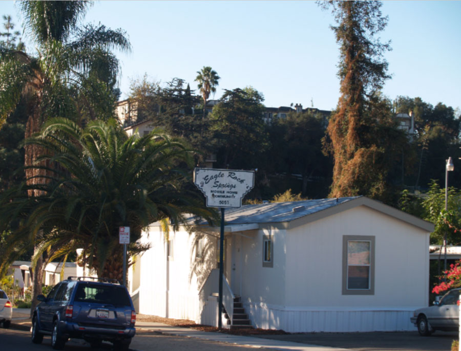
The Eagle Rock Springs Mobile Home Community, photographed in 2006.
Mrs. DelFosse and her husband had arrived in Eagle Rock in 1912, and soon became owners of "approximately one acre of tree covered grounds with a small artesian lake supplied by several flowing artesian wells." Water from the springs ran all the way to Eagle Rock Boulevard and then on to York Boulevard, with watercress and willows lining the way.
In those early days, the pool was a watering place for livestock. Bob Cota described seeing 30-40 head of cattle drinking from the pond, eating the grass at the pond's edge. Grass grew year-round: it was on the north side of the hill.
The DelFosses began the Auto Camp in 1922, since auto tourists regularly had sought permission to camp at the site. Tenthouses were provided to accommodate tourists. Later, these were replaced by framed structures. By 1943, the Auto camp offered 17 furnished cabins and 9 licensed trailer spaces.
The pond became the swimming hole of a generation long gone. At least one married couple met there, and it was a favorite place for adventurous boys.
The pools were flanked by oak trees, willow, and cattails. Fraleigh says, "To get to [the pools], you had to push through the underbrush." At one time, there were even catfish in the water. "I know, Cota says, "because I went down and fished out a couple for myself once."
Powell Greenland described a stream emerging from the North end of the Auto Court, flowing west, before turning toward the Southern end, where it filled a pond with ducks. "I had a Saturday Evening Post route. I made a point to go there to get a drink of water on my route. It was very good on a hot day."
By the late 40s, the pool was encased in concrete, the brook that Greenland described was diverted through underground pipes, and the "spring" was now an iron pipe jutting out from the same pool.
Yet, the water was as good as ever. In the 1940s, Max Norris used to get his regular drinking water at the spring, and remembers all the other locals did as well-- from Hill Drive down to Chickasaw.
The supply was plentiful enough that if a truck from one of the bottling plants came up short before finishing their delivery route, they would stop at the spring and fill the rest of their bottles there. Norris remembers trucks from one of the water companies on Figueroa regularly pulling up for refills.
In 1952, Scott Wilson moved into a house on Hermosa whose backyard was adjacent to the spring. At that time, the spring was simply water coming out of a hole in the ground, and the amount of water less than a sink faucet. The flow was constant, year round. He remembered a new owner of the trailer park attempting to reorganize and regrade the land. These efforts resulted in water flowing where he didn't want it. The wall he built to remedy this only caused water to flow onto the neighbor's backyards, turning them into swamps. Scott was obliged to install a 4" pipe to drain his backyard.
Though the pond must have been long gone by 1961, water still ran down the side of Chickasaw to the storm drain, allowing moss to grow. Today, the stream continues to flow, though 6 feet underground. The only visible evidence of the spring is an array of pipes in the parking lot and the water spurting out of the sump pump across the street twice a day.
page 8
7 Flooding, Then and Now
In his memoirs, pioneer settler Cromwell Galpin paints a vivid picture of farmers at the mercy of unpredictable rain patterns during the flood of 1889-90.
"… In October of 1889 it began to rain, and it kept on until nearly seven inches had fallen; it also kept on raining a lot more in the months following, until May 1890, the local rain gauge indicated forty-two inches and Eagle Rock Valley was afloat, though the highest mountains still poked their heads above the flood."
"When the water receded all the apples, apricots and peaches and Brown's walnuts had been drowned; in the course of time to be cut up for fuel wherewith the Eagle Rock farmer was just moderately glad to eke out a substitute for money he might have made by farming. The whole Sycamore stretch of flat ground from Park Avenue (Fair Park) to the city limits, and west of Central Avenue (Eagle Rock Boulevard) was a huge morass that grew up immediately to willows, or where the water was still too deep, to cat-tails or tules. The willows grew thirty feet high in a year, and were so close together as to make the fight for existence a struggle for standing room. Then the willows were hewed with axes and snagged at with scythes and wallowed around with plows until a ditch had been cut from Park Avenue to below city limits, and the surplus water drained off.
Eagle Rock settlers may have been vexed at willows growing 30 feet in a year where there were previously none to be seen. But a likely explanation for this is suggested by Jotham Bixby in an oral history recorded by County flood engineer James W. Reagan in the 1910s. Bixby describes willows springing up all over Compton, Watts, and Huntington Park after the flood of 1868. He explained that such "marsh growth" had previously characterized the land but hadn't been evident for years because it had been so thoroughly grazed by cattle, especially during very dry years.
Such thick vegetative growth once slowed the movement of water over land to the extent that rains seldom caused damage. In fact, slow-moving waters were welcomed by farmers. They looked forward to deposits of rich silt which would increase their lands' productivity. Ironically, the rich soil that originally drew Galpin to Eagle Rock may have been the direct result of the same kind of flood that took him by surprise in 1890.
Countless miles of concrete stormdrains now move rainwater quickly into the sea rather than allowing it to seep slowly into the ground to replenish streams and aquifers. Our excessive use of hardscaping causes water to move incredibly rapidly into low-lying areas, causing sudden and severe flooding.
Scarcely a few decades after willows were last growing in Eagle Rock valley, this phenomenon was already painfully evident:
"Peggy Jakobsen... was returning from school and finding the crossing at Caspar Avenue under water, walked east to Shearin Avenue and attempted to cross at that point. Caught in the grip of a whirling eddy, the child was swept from her feet and was being carried toward certain death when she was seen by her rescuers. The strength of the current carried one of the priests off his feet but his companion reached the child..." (The Eagle Rock Reporter and Sentinel, April 9, 1926)
Though sudden and severe flooding could be dangerous, it was welcome by some students when it led to the cancellation of school. Bert Fraleigh described the floods of 1933 and 1941 when "Yosemite Drive... reverted to a riverbed, with water flowing curb to curb for two weeks, and we could not get to Eagle Rock High School for several days."
page 9
8 Sycamore Drive
The land where pioneer Eagle Rock settler Cromwell Galpin farmed was once ideal for crops: even without artificial irrigation.
The Los Angeles Times wrote about Eagle Rock, "It is surprising how long the soil here retains its moisture. We plant our vegetables after all the rains are over, and they mature and reach perfection without any irrigation... irrigation being unnecessary for anything except oranges."
Eagle Rock was not especially unique in this regard. Ludwig Louis Salvator wrote in 1876 of the "tablelands" of Los Angeles, that properly prepared soil could produce "nine good annual harvests out of ten, without irrigation, of castor oil beans, Indian corn, barley, alfalfa, potatoes, and various kinds of vegetables."
Galpin described how during even the particularly dry year of 1885, rain from the previous winter was still draining down from the surrounding hills; keeping his apple and apricot trees happy.
Even in Eagle Rock, however, farmers could not escape that irrigation would become a pressing issue. As the water table dropped, farmers experimented with methods of boring wells and pumping water. These efforts were not particularly rewarding.
"With the change in available water," Galpin writes, "came changes in cultivation and in crops planted. Barley and oats gave way largely to garden truck and tomatoes, yielded to small fruits and berries such as strawberries." Barley and oats require 1388 and 1597 cubic meters of water per ton. Tomatoes and strawberries, which superseded those crops, require only 184 and 276. (Figures from www.waterfootprint.org)
9 Farming in the Late 1800s
The land where pioneer Eagle Rock settler Cromwell Galpin farmed was once ideal for crops—even without artificial irrigation.
The Los Angeles Times wrote about Eagle Rock, "It is surprising how long the soil here retains its moisture. We plant our vegetables after all the rains are over, and they mature and reach perfection without any irrigation… irrigation being unnecessary for anything except oranges."
Galpin described how during even the particularly dry year of 1885, rain from the previous winter was still draining down from the surrounding hills— keeping his apple and apricot trees happy.
Galpin cites "lessened rainfall and better drainage" as reasons irrigation eventually became a pressing issue. As their livelihood depended increasingly on adequate access to water, farmers experimented with methods of boring wells and pumping water. This was no easy matter, and "[w]ith the change in available water, came changes in cultivation and in crops planted. Barley and oats gave way largely to garden truck and tomatoes, yielded to small fruits and berries such as strawberries."
page 10
10 Eagle Rock Boulevard
In the 1880s, several small tributaries emerged aboveground near the intersection of York and Eagle Rock Boulevards. These combined into a flow which followed a deep and meandering streambed before disappearing into the graveled banks of the Los Angeles River.
Cromwell Galpin describes how during this era, Eagle Rock Boulevard used to stop at the southern limit of Eagle Rock, making the journey to Los Angeles most vexing during the rainy season. The road would have stopped before reaching the low and swampy area from which the tributaries arose. "… [H]e that went farther afoot, took his choice of a route across or around the hills, while he that drove a horse went where he could, across a morass if he turned to the right, and into the water if he went ahead; he that turned to the left went farther and fared worse, for he got into bottomless and almost boundless mud over in what is now a very pleasant part of the New York Valley..."
By the time of the USGS survey in 1894, the stream on Eagle Rock Boulevard was limited to seasonal flow, and its course had become simplified and relatively linear.
Streetcar tracks built on Eagle Rock Boulevard in the early 1900s were raised in several locations to accommodate water flow. An old timer describes the configuration of Eagle Rock Boulevard, as it approached the Los Angeles River:
a two lane boulevard, with a small creek running down the middle of it. It was road, creek, trolley tracks. At the bottom of Avenue 31, there was a small wooden pedestrian bridge over the creek, between the road and the tracks. Moss Avenue had another bridge... About every two streets up the Boulevard had a bridge over the creek to reach the trolley...
page 11
11 The Cienega
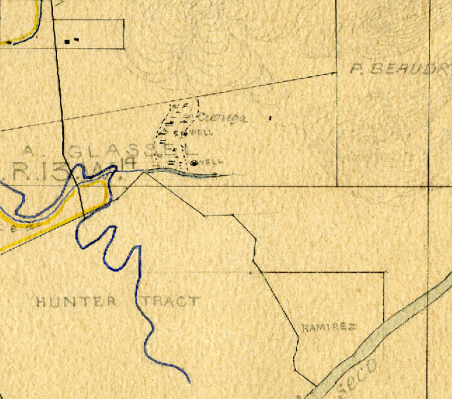
An early survey showing the cienega and two wells, ca. 1880s. (California State Archives)
This illustration from the same decade portrays the Cienega del Garvanza region more idyllically. It is part of a real estate advertisement for Boulevard Tract. (Huntington Library)
In 1876, Ludwig Luis Salvator made note of the "Cienega del Garvanza, a small green swamp with clumps of bunch-grass and at the bottom, Sacate de Matico, which never dries out." By 1880, Glassell began to develop the cienega as a water source by drilling wells. Water flowed from the wells without the aid of wind, steam or gas.
Around the turn of the century, the Huggins family lived in this area. A stream "cut deep through the rear of the property, feeding into a lake that sprawled onto what is now El Paso Drive. Here, the placid pool was a favorite spot for Sunday picknickers who paused to water their horses."
Bob Moffitt tells me that his mother-in-law, Esther Kratz, remembered this marshy area as "Skunk Hollow". She described the artesian wells as not simply bubbling out of the ground—but actually shooting up, spurting into the air.
The proliferation of bottling plants in this area in the 30s would have done much to dry up the Cienega del Garvanza. However, the city's attempts to maintain storm drains on the section of York Boulevard by the Cienega has barely kept pace with the winter rain's persistence in reoccupying this former swamp. The drains beneath the boulevard had to be torn up and renovated "a dozen or so times" throughout the last century.
page 12
BOTTLED WATER
Though the City of Los Angeles is well known for its long distance antics for obtaining water, Northeast Los Angeles was historically the site of many bottling companies.
Bert Fraleigh wrote of the 1930s: "We had Los Angeles city water piped from a small covered reservoir on top of the South Hills behind Rock Glen Avenue. I think they filled the reservoir from the LA Aqueduct... The water wasn't very good, so almost every family subscribed to the waterman who came by weekly delivering allegedly distilled water in blue glass five gallon bottles…"
The following are just a few stories about our local bottled water…
12 Sparkletts
In August 1925, a new water company announced they would temporarily give unlimited quantities of their product to anyone who brought their own container to fill. This promotional blitz, coinciding with the heat of summer, created instant demand for Sparkletts.
Clever marketing magically transformed the water of the Cienega del Garvanza into "not only a pure water, but a "live" water". It was advertised to be 85.4% saturated with Oxygen—the cause of its special sparkle. Promotion of Sparkletts was so successful that within a couple months of the opening, the Highland Park News Herald reported "demand for Sparkletts now is so large that the concern has difficulty in filling it."
In 1929 Sparkletts announced the construction of a new plant built in a "Moorish" style by Richard D. King, to symbolize an oasis. The new facilities increased maximum capacity to 125,000 g/day. The company spent one third of its income on advertising.
Despite the company's ambitions, Sparkletts kept close ties to the Eagle Rock community. In the 1930s the company hosted local art exhibits on its premises as well as meetings of organizations such as the Sierra Club and the California Association of Sanitarians. Representatives of Sparkletts served on the Eagle Rock "Y" board, and the company supplied water to local events. The company hired Eagle Rock youth such as Bert Fraleigh and Powell Greenland to move boxes or inspect soda during the summer.
In the mid 30s, at least three distributors of bottled water besides Sparkletts operated out of the old Cienega del Garvanza area.
It is said that Sparkletts is now primarily selling treated tap water, i.e., water imported from Northern California, the Owens Valley and the Colorado River.
Sparkletts was sold to Foremost Dairies in 1964, which was in turn acquired by MacKesson-Roberts, based in San Francisco. More recently, the company was bought by Danone, and then, by DS Waters. The famed Moorish building in the neighborhood is now closed, due to damage from the 1994 Northridge earthquake. To order the water sold by the company that began in our midst, one must go through "water.com". Phone calls to inquire further into our local history, bounce endlessly around DS Waters' corporate offices in Georgia.
page 13
13 Poland Rock and Glen Rock Springs
For a brief moment before the turn of the last century, "Poland Rock" water was said to originate from an Eagle Rock tunnel.
The Los Angeles Times reported in 1890,"Some months ago, H.B. Botsford of Eagle Rock Valley discovered a spring of pure water on his place. To get back of all alien ingredients and reach the water in its purest state he drove a tunnel into the rock 350 feet, and thus got at the fountain head where the water comes from the strata of clean granite rock… It is no marvel that Poland Rock water is fast becoming popular in Los Angeles."
Eventually, the property was sold to W.C. Weaver, who renamed it "Glenn Rock Spring." By 1902, the spring apparently ceased production, for Weaver had subdivided the land, and the tract became "Glen Rock Villa."
14 Yosemite Waters
The Yosemite Waters brand is shipped throughout our region, but hardly known in our own neighborhood. The water still originates from an artesian well near the banks of the Arroyo Seco, on a parcel of land named "Spring Tract." There were once multiple springs nearby, but these have since been capped. In 2006, when I last visited, I was told that an overflow of 3 gallons/minute drains into the Arroyo Seco channel.
15 Garvanza Springs
Let us turn back to the travels of the Archduke of Austria, Ludwig Louis Salvator in 1876, who after crossing over a low saddle of hills from Eagle Rock Canyon, found himself at the Aguaje del Garvanza: "This contains a small ranch with pastures, wooden houses with porches, and sheep-corrals. Nearby a spring flows."
Only several years after the Archduke's visit, the Garvanza Spring would be supplying a new reservoir. Though reservoirs were an established way to maintain a year-round water supply from existing springs, this was a step down in water quality for Garvanza residents, who had been accustomed to having their water piped directly from the arroyo springs.
This reservoir is the oldest in Los Angeles, and still in use. The low lands near the reservoir are the site of Luther Burbank Middle School and Garvanza Elementary School.
page 14
16 The North Fork
Though little trace of it remains above ground today, the North Branch of the Arroyo Seco was once a defining feature of the "vast meadow" that would eventually become Highland Park. Archduke Ludwig Louis Salvator noted the stream in his account of his travels through Los Angeles, which were published in 1876. Building a railroad over the stream near what would become Sycamore Grove Park, altered its surface appearance irretrievably. But even so, the stream persisted aboveground in places into the earliest years of the 1900s.
According to Chas. Elder, who wrote about the stream in the mid-twentieth century, the North Branch's main source was "a great spring situated just west of North Figueroa at Springvale Drive" whose flow was once "as big around as a water bucket." Smaller springs added to this flow, most significantly Glenn Rock Spring, at the head of Milwaukee Avenue.
Of the North Branch, Elder wrote:
"This little river had a good stream of water flowing down it even in the driest seasons, and was full of mountain trout and catfish even up as far as York Boulevard. I myself have seen boys pulling fish weighing half a pound as far north as North Avenue 51 and Buchanan Streets. The North Branch from Springvale Drive to Meridian Street flowed through a beautiful little glen about 40 feet deep and 200 feet wide in places, which was full of most beautiful ferns. Along the banks of the stream were hundreds of fine old oak and sycamore trees."
A map from the 1880s, shows the stream sinking underground into the sandy banks of the Arroyo Seco even before reaching present-day Sycamore Grove Park.
By the late 1920s, the North Branch's reach had been extended and tamed for middle class urbanites by routing it through the Park in a neat concrete liner. A wading pool filled by the stream became a central feature of the park. Idyllic landscaping around the pool included bamboo clumps, night lighting, and rustic benches. The path of the stream through the park is indicated on maps from the 20s and 30s.
Adventurous boys of that era would follow the creek down into the wilder banks of the Arroyo Seco, where cattails and willows reigned. Henry Welcome was one of those boys:
"Sometime in the dim past a large pond had developed in the Arroyo Seco. As time marched on, the youths of the neighborhood had enlarged the pool, adding a raft or two made from abandoned railroad ties. As little fellows we used to catch, in mother's canning jars, minnows and crayfish. We called them 'crawdads,' taking them and the tiny fish home in the evening, where in a few days they usually died of neglect. As we grew bigger we ventured into the big pond among the tules..."
After a devastating flood in the 1930s, a large storm drain was built to convey the waters of the North Branch under the Park, and the wading pool disappeared.
That the stream was missed by many is evidenced by Fred Allen's observation in mid-century that "the creek is still placed [in paintings of Sycamore Grove Park] by some artists, who think it adds to the natural beauty of the area."
A small grove of walnut, sycamore, and oak trees just northwest of Arroyo Seco Museum Science Magnet School is the only remaining fragment of the large grove that once shaded the route of the creek.
Very near where the stream had once emerged onto the flood banks of the arroyo at the northern end of Sycamore Grove Park, a particularly prolific spring was tapped by a succession of commercial bottling companies between 1904 and 1970. This spring was most recently known as "White Rose Spring." Though the spring has been capped, the owner of the building next door told me that whenever there is heavy rain, or if the ground is disturbed during earthquakes or trembles, water reappears through small fissures in the concrete.
In the middle of the last century Chas Elder had mourned that the "great spring" from which originated the North Branch had dwindled to the size of his arm: "Newcomers will laugh at the idea of a river with fish in it wandering through Highland Park, but the old-timers of whom there are over 40 who have lived here over 50 years, will wipe away a tear and sorrowfully commence "I remember when--"
Though we can only imagine what the North Branch was like during Elder's childhood, a surprisingly simple solution has been proposed that could allow the North Branch's waters to flow once again through Sycamore Grove Park. An 'alternative' streambed would be laid through the park. During storm events, flows in excess of the safe capacity of that streambed, would bypass the intake and continue through the existing storm drain under the park. Dan Sharp, an engineer for the Watershed Management Division of LA County Public Works, suggested that this solution for providing habitat, public use, and quality of life benefits would come at a fraction of the cost and risk of a full-scale daylighting.
Maybe one day residents of Highland Park will laugh, saying, "Remember when the North Branch flowed under the park through that big pipe?!"
Sycamore Grove Park, with the concrete-lined North Branch of the Arroyo Seco in background. (Security Pacific Collection: Los Angeles Public Library)
The summer flow of the North Fork as it joins the Arroyo Seco, between Debs Park and Sycamore Grove Park.
page 15
More Stories About Buildings and Water
Instead of following the natural topography, many subdivisions in Northeast Los Angeles have been gridded right over perennial and seasonal streambeds. Thus, despite the elaborate flood control and drainage system that is now in place, stories of underground waterflows causing flooding, damage, or slippage under buildings are still commonplace.
According to Robert Glass Cleland, beginning excavations for Johnson Hall at Occidental College in 1912 unearthed a waterflow that "defied all efforts at control." The underground stream nearly jeopardized the realization of the orderly Mediterranean-inspired campus that was the brainchild of Myron Hunt.
A similar incident recurred 46 years later, when excavation for Norris Hall of Science began.
In both instances, instead of revising the campus layout to accommodate the property’s natural assets, the university shunted the waterflow underground so construction could continue exactly as planned. The cute little water fountains now decorating the campus’ central mall belie the area’s hydrological richness.
A story Bert Fraleigh told me, however offers a more creative approach to working with our area’s hydrology. He tells me that from the 20s until it was destroyed by a fire in 1941, the swimming pool of the Blankenship family, on the north hills above Live Oak View, was filled from "a very small spring and stream trickling down in a very small canyon above the pool."
It’s time to consider how our region’s hydrological richness can be integrated into our urban landscape in a way that enriches our experience of living in this city.
footnotes
ACKNOWLEDGMENTSThank you to all the North East Los Angeles old timers who shared their memories with me, and especially Eric Warren of the Eagle Rock Valley Historical Society for guiding my research, sharing discoveries, and offering encouragement. Tim Brick's exhibition "Flowing Waters, Fruitful Valley" opened my eyes to the pre-aqueduct history of water in Los Angeles. Jessica Hall's philosophy of stream-seeking, practiced throughout the entire LA metropolitan area, and her important work on the North Fork of the Arroyo Seco, was inspirational. She generously shared with me her own sources and contacts. Ann Dove, Powell Greenland, and Michael Hart were also incredibly generous. Nicole Antebi suggested formatting my research in the form of a bike tour. Liz and Shay of C.I.C.L.E. expertly organized the route for the first group bike ride in 2008. May others continue to add to this story, which I've only just scratched the surface of... SOURCESArroyo Seco Watershed Management and Restoration Plan. Northeast Trees, 2006. Bra, Brian, Jessica Hall, Chiung-Chen Lian, Greg McCollum. Seeking Streams: A Landscape Framework for Urban and Ecological Revitalization of the Ballona Creek Watershed. Pomona: 2001. Brick, Tim, "Flowing Waters, Fruitful Valley: a Brief History of Water Development in the Arroyo Seco," brickonline.com (accessed 2006-7). Cleland, Robert Glass. The Cattle on a Thousand Hills. San Marino: The Huntington Library, 1951. Cleland, Robert Glass. The History of Occidental College, 1887-1937. Los Angeles: The Ward Ritchie Press, 1937. Crocker, Donald W. Within the Vale of Annandale, A Picture History of South Western Pasadena and Vicinity. Pasadena: A Fundraising Project of Scout Troop 35, 3rd ed.,1975. Crump, Spencer. Henry Huntington and The Pacific Electric. Corona del Mar: Trans-Anglo Books, 1978. Dumke, Glenn S. The Boom of the Eighties in Southern California. San Marino: Huntington Library, 1944. Eagle Rock: Its History and Legends. Eagle Rock: Women's Twentieth Century Club, 1912. Eckbo , Garrett. Urban Landscape Design. New York: McGraw Hill Book Company, 1964. "The First People of Eagle Rock" by Bernice Eastman Johnston. Eagle Rock Valley Historical Society. A First Collection of Eagle Rock Histories, undated brochure published by Eagle Rock Valley Historical Society. Eagle Rock Valley Historical Society. Fisher, Charles J. and the Highland Park Heritage Trust. Highland Park. Charleston: Arcadia Publishing, 2008. Fredeen, Larry. Post on TrainFoamers.com, 1-5-2005 (accessed 2006). Friedricks, William B. Henry E. Huntington and the Creation of Southern California. Columbus: Ohio State University Press, 1992. Gumprecht, Blake. The Los Angeles River: its Life, Death, and Possible Rebirth. Baltimore: The Johns Hopkins University Press, 1999. Hall, William Hammond. Irrigation in California (Southern): Report of the State Engineer of California on Irrigation and the Irrigation Question. Sacramento: J.D. Young, Supt. State Printing, 1888. Welcome, Betty, ed. Henry Welcome. "The History of Eagle Rock." Eagle Rock Valley Historical Society. Howard, Danny and Ray Younghans. Highland Park, Eagle Rock, Mt. Washington & the Harnsberger's. Eagle Rock: Donna Harnsberger, 1990. Los Angeles City Directories 1884-1942. Los Angeles and Pasadena City Directory, 1887. Los Angeles Times Classified Directory, 1917-18. Mendenhall Walter C. Foothill Belt and Central Coastal Plain Region of Southern California. USGS Water-Supply Paper 129, 1908. Moure, Nancy, "Background for Lecture Given at Eagle Rock Valley Historical Society," californiaart.com, 7-18-2000 (accessed March, 2006). Myers, William A. Iron Men and Copper Wires: A Centennial History of the Southern California Edison Company. Glendale: Trans-Anglo Books, 1986. Orsi, Jared. Hazardous Metropolis: Flooding and Urban Ecology in Los Angeles. Los Angeles: University of California Press, 2004. Post, Robert C. Street Railways and the Growth of Los Angeles. San Marino: Golden West Books, 1989. Preston, William. "Serpent in the Garden: Environmental Change in Colonial California." In Contested Eden: California Before the Gold Rush, edited by Ramon A. Gutiérrez and Richard J Orsi, pp. 260-298. Los Angeles: University of California Press, 1998. Raab, L. Mark. "Political Ecology of Prehistoric Los Angeles." In Land of Sunshine, edited by William Deverell and Greg Hise, pp. 23-37. Pittsburgh: University of Pittsburgh Press, 2005. Reagan, James P. Early Floods in Los Angeles County: Notes by James P. Reagan, County Flood Control Engineer, 1915. Reid, Hiram A. History of Pasadena. Pasadena: Pasadena History Company, 1895. Rolle, Andrew F. Occidental College: The first seventy-five years 1887-1962. Los Angeles: Occidental College, 1962. Salvator, Ludwig Louis. Los Angeles in the Sunny Seventies: A Flower from the Golden Land. Translated by Marguerite Eyer Wilbur. Los Angeles: Bruce McCallister, Jake Zeitlin, 1929. "Saving the Rock," Eagle Rock Valley Historical Society Newsletter, Fall 2005. Eagle Rock Valley Historical Society. Schiffman, Paula M. "The Los Angeles Prairie." In Land of Sunshine, edited by William Deverell and Greg Hise, pp. 38-51. Pittsburgh: University of Pittsburgh Press, 2005. Seeing Los Angeles by Yellow Car and Bus, undated booklet published by Los Angeles Railway. "Sparkletts Water Plant being enlarged by Big New Building," Eagle Rock Advertiser, 5-17-29. Stein, Eric D., Shawna Dark, Travis Longcore, Nicholas Hall, Michael Beland, Robin Grossinger, Jason Casanova, and Martha Sutula. Historical Ecology and Landscape Change of the San Gabriel River and Floodplain, SCCWRP Technical Report #499. Southern California Coastal Water Research Project, February 2007. Johnston, Francis. "The Stimson Lemon Ranch." Eagle Rock Valley Historical Society, 1948. Thompson, Nelda, "Hugginsville Lives Again," Highland Park Herald News, undated clipping in the California Index of the Los Angeles Public Library. Warren, Eric, ed. Untitled Eagle Rock Notebook. Eagle Rock Valley Historical Society. Waldie, D. J., Holy Land: a Suburban Memoir. New York: W.W. Norton, 1996. Biographies of Mrs. John Lorenz, Frances Hatch Fey, Mrs. Beth Ellenwood Newhan, Cromwell Galpin, Amanda Reiter, and others, as recorded by the Eagle Rock Valley Historical Society. Eagle Rock Valley Historical Society. NEWSPAPERSEagle Rock Sentinel, Highland Park News Herald, Los Angeles Times WEBSITESwaterfootprint.org, Water Footprint Network. (accessed December, 2008) historichighlandpark.org, Historic Highland Park Neighborhood Council. (accessed June, 2008) eaglerockhistory.org, Eagle Rock Valley Historical Society. (accessed June 2008) digitallibrary.usc.edu, USC Digital Library MAPSca 1871 Ranchos San Rafael & La Canada, LA County Surveyors Map # 7566 with superposition of modern roads marked by Eric Warren, ERVHS 1880 and 1888 William Hammond Hall various manuscript and draft versions 1900-1928 USGS maps 1927 Eagle Rock and Vicinity, Pasadena Museum of History Sanborn maps 1930 and 1930-50. ca 1937 Edward Roberts Real Estate Insurance Map, at Eagle Rock Valley Historical Society City of Los Angeles Bureau of Engineers storm drain maps Baist, G. Wm. Baist's Real Estate Atlas Surveys of Los Angeles, California: Compiled and Published from Official records, Private plans, Actual surveys by G. Wm. Baist, Surveyor. Philadelphia: G. Wm. Baist, 1921. ARCHIVESFairchild Collection at Whittier College Geoscience Support Services Pasadena Museum of History Eagle Rock Historical Society The Huntington Library LA DWP Archives CONVERSATIONS/CORRESPONDENCE WITHTim Brick, Bob Cota, Ann Dove, Troy Evans, Charles J. Fisher, Bert Fraleigh, Powell Greenland, Fred Guapo, Ed Kluss, Don Krotser, Wanda Kuenzli, Jessica Hall, Michael J. Hart, Kenneth Kent Sr., Elmer Lorenz, Lupe, manager of Eagle Rock Springs Mobile Home Community, Bill Mac Learn, Dick Malott, Bob and Frances Moffitt, Jennifer Murphy, Virginia Neely, Max Norris, Adrian Saxe, Connie Saxe, Art Snyder, Paul Soifer, Lucy Spurgeon, Doris Karger Thielen, Tom Topping, Nancy Trerise, Merritt Tritch, Eric Warren, Scott Wilson As this research is ongoing, questions, comments, clarifications and corrections are welcome. Contact: |
RELATED PLACES Los Angeles